|
HIKE: Upper Pocosin Mission. Round trip 1.9 miles; total climb about 425
feet; time required 1:55. An easy hike, via fire road, to the site of a former
church and mountaineer settlement. See map, page 181. You're at the right-
hand edge, above center. Your route is N-M-L-M-N
Follow the fire road, past the chain and the A.T. crossing, and past the side
trail to the cabin. About a mile from the parking area the road levels out and
swings left. Look for a concrete marker post on the right, near the start of the
yellow-blazed Pocosin trail. As you turn onto the trail, the first ruin is about
100 feet diagonally left. It was part of the Episcopal Mission here—not a
mountaineer cabin. Explore if you wish, remembering that snakes like to take
cover under old lumber piles.
Twenty yards from the ruined house are the steps of the church. The
church is gone, and its foundation is crumbling. As I write this, two walls of a
small side room are standing, one with a wooden door frame. There are
various graffiti on the frame, including: "E. B. Samuels born here 1915,
visited here July 21, 1974." "This church has gone up and down in my lifetime,
W. E. Samuels."
Twenty-five yards beyond the church steps are the ruins of a wooden
structure, now unidentifiable, under a large chestnut oak. The vines on the
upper limbs of the oak are loaded with grapes in autumn—but way up out of
reach. On the other side of the Pocosin trail, which once was a road, and beyond
the remains of a fence, is an abandoned cemetery with fieldstone markers,
and the site of at least two houses. Explore if you wish, then return to your car
the way you came.
|
|
HIKE: Pocosin Mission and South River Falls. Circuit 8.5 miles; total climb
about 1,830 feet; time required 7:30. A long and tiring hike which includes
ruins, a cemetery, and the falls. See map, page 181. Your route
is N-M-L-K-J-D-C-B-F-M-N.
As above to Pocosin Mission, and continue on the abandoned road, which
is now the Pocosin trail. Descend to the small stream, then climb easily uphill
for a while. Some parts of this trail may be overgrown in summer, but you
should have no trouble following the old roadbed. Rattlesnakes have been
reported here; carry a stick if the grass is high, and use it to part the grass in
front of you as you walk.
About 1.2 miles from the mission, the trail flattens out in an overgrown
grassy area and enters an old orchard, which still produces quantities of
edible fruit. Watch for a marker post where the trail turns sharply to the right.
The less-used trail goes about 150 yards diagonally left to the South River
Cemetery—which is fenced, carpeted with periwinkle, and rather attractive
as cemeteries go. Although inside the Park, and though overgrown with black
locust and other pioneer trees, the cemetery is still active. None of the graves
with inscribed markers is very old.
Return to the main trail and turn left. Go about 200 yards to the South River
fire road, with an old stone wall on your left for a part of this distance. Turn
right on the fire road, which runs along the Park boundary (marked by red or
orange blazes.) After 250 yards the boundary turns 90 degrees to the right,
and you enter a Virginia Wildlife Area. You re-enter the Park where a chain
blocks the road. Less than half a mile beyond the chain, a less-used road
comes in at a sharp angle from the left. Turn left onto this road, which soon
narrows to a trail and, less than half a mile from the junction, reaches a
marker post where a trail comes in from the right. (Ahead, it's three-quarters
of a mile to the bottom of South River Falls.) Turn right and go about 250 yards
to a viewpoint, on your left, with a fine view of South River Falls.
The falls has a total drop of 83 feet. Halfway down, the stream divides, so
that the falls has the form of an inverted "Y". From the observation point
return to the trail and turn left, passing along the edge of a steep gorge, to the
head of the falls. (Keep going; there's no view from the top of the falls.)
Continue uphill, with a couple of switchbacks, to the A.T. crossing 1.2 miles
from the falls observation point. (Ahead, uphill, it's a tenth of a mile to the
South River Picnic Area, which has water and toilets.)
Turn right on the A.T. Cross the South River fire road after half a mile, and
continue another 2.9 miles to the Pocosin fire road. Turn left and go less than
0.1 mile to your starting point.
|
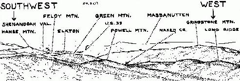
MILE 61.3, BALDFACE MOUNTAIN OVERLOOK. Elevation 3,345 feet.
The view here is especially attractive because of the rocky ledge beyond the
wall. The sketch names some of the things you can
see.
 |
| View from Baldface Mountain Overlook |
|---|
Trivia: I can't find "Baldface Mountain" on any map. The nearby summit
to your left is nameless on the maps. In the 1930's there was a CCC camp
half a mile south of here; its mail was addressed to "Baldface, Va.," but was
delivered through the Elkton Post Office.
MILE 61.8, SERVICE ROAD, west side; ABANDONED ROAD, east side.
A.T. access. See map, page 181; you're a little left of upper center. There's
parking space in the grass on the east side, just north of the abandoned
road.
The service road on the west side was once used by the Park's
maintenance division for earth storage. It goes about a thousand feet, then
ends. The area is fairly level, and still relatively open.
Along the east side of the Drive here, on both sides of the abandoned
road, there was a CCC camp during the 1930's. The abandoned road goes
an eighth of a mile to the A.T., then continues for 75 yards to a sort of
amphitheater in front of the quarry face. There is little evidence of the CCC
occupation except a few bricks, a few lumps of coal, a little scrap metal, and
some piles of decaying chestnut boards near the quarry.
MILE 62.7, SOUTH RIVER OVERLOOK, elevation 2,950 feet. The
overlook has a V-shaped view down the valley of South River and out to the
Piedmont. The high point diagonally right is Saddleback. A few feet north of
the overlook, a fire road leaves the Drive on each side.
On the west, the Dry Run fire road goes about 2.0 miles to the Park
boundary. The Dry Run falls are off the road, but worth a trip by experienced
explorers. About 1.8 miles from the Drive, the fire road makes a sharp turn
to the right. After you complete the turn the falls will be diagonally ahead
and left, straight downhill, about an eighth of a mile away. If there's a good
flow of water, you should be able to hear the falls from the road. As I said,
experienced hikers only.
On the east, the South River fire road (point "G" on the map, page 181)
crosses the A.T. about a quarter of a mile from the Drive (at point "F".) The
road is an alternate route to the South River falls; but I recommend starting
from the picnic area, a tenth of a mile to the south.
MILE 62.8, SOUTH RIVER PICNIC AREA. A.T. access; hikes to South
River Falls and South River Trail Maintenance Building. Open all year; drive
in. The head of the South River Falls trail is on your right as you drive into
the third parking area. It crosses the A.T. about 150 yards from the road.
Distances on the A.T.: North (to the left) it's 3.4 miles to the Pocosin fire
road near Mile 59.5 on the Drive. South (to the right) it's 3.0 miles to the
Drive crossing in Swift Run Gap, Mile 65.5.
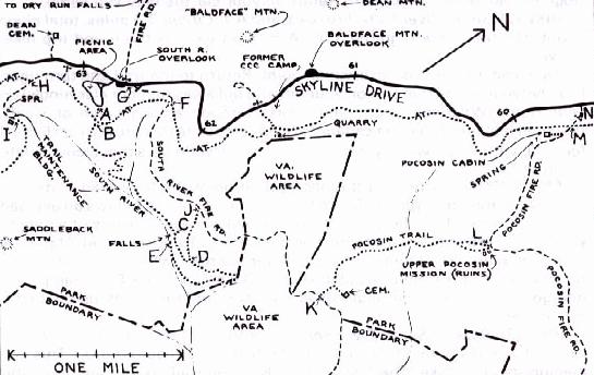 |
| Map of Pocosin—South River Area |
|---|
South River Falls is at the head of a deep and precipitous rocky gorge. It's
the third-highest falls in the Park, with a drop of 83 feet in two stages: first,
a single stream falls to a pool about halfway down the cliff, where it divides
and falls the rest of the way in two separate streams. The falls are best seen
from an observation point a little way downstream, on the left bank of the
gorge. I will suggest three different hikes to the falls, listed here in order of
increasing difficulty. See map above.
- Falls observation point and return. Route: A-B-C-B-A.
- Falls observation point; return by fire road and A.T. Route: A-B-C-D-J-
F-B-A.
- Base of the falls and return by fire road. Route: A-B-C-D-E-D-J-F-B-A.
|
HIKE: (1): South River Falls. Round trip 2.6 miles, total climb about 850
feet; time required 2:25. A moderately easy hike; the return trip is a steady
climb.
Follow the trail past the drinking fountain and continue downhill, crossing
the A.T. in less than 0.1 mile. Continue downhill on a long straight stretch
through an overgrown clearing; the stone walls to the left are evidence that
this was once a cornfield or pasture. (Wildflower note: the flowering spurge,
Euphorbia corolata, is common along this trail; its small white flowers bloom
in mid-summer.) The trail swings left, descends by switchbacks, then
straightens out again as the stream joins it on the right.
Cross a tributary stream (often invisible under the rocks, but clearly
audible.) Looking ahead you can see what appears to be sky at the base of the
trees—a clear indication that the bottom of the hollow drops away suddenly,
and the stream plunges over a waterfall. After another hundred yards you'll
come to a concrete trail marker on the left, and maybe a pile of brush at the
right (to discourage people from going to the top of the falls. Reason: you can't
see the falls from the top, but you can risk your life there.)
Continue another 0.1 mile to a second trail marker. The observation point
is 30 feet to the right—a ledge on which the Park has built a guard wall. From
there you have a fine view of the falls and, across the gorge, of the northeast
ridge of Saddleback Mountain. Return to your car the way you came.
|
|
HIKE (2): South River Falls, fire road, and A.T. Circuit 3.3 miles; total climb
about 910 feet; time required 3:05. Almost as easy as the round-trip hike,
above.
As above, to the falls observation point. Return to the trail and turn right.
Pass between cliffs that rise on your left and fall away (but not alarmingly) on
your right. (Wildflower note: you'll pass through a long patch of small-flowered
leafcup, Polymnia canadensis—a composite that grows from 6 to 10
feet tall, with large, weirdly-cut leaves, and yellow flowers that bloom in late
summer.)
About 250 yards beyond the observation point the trail dead-ends at a
concrete marker post (point "D" on the map), in a trail that follows an old road
trace. The base of the falls (hike three, below) is three-quarters of a mile to
your right. Turn left. The trail soon becomes more obviously a road. About 0.4
mile from point "D" it joins the South River fire road, which comes in on the
right (at point "J"). Continue uphill another 0.8 mile to the A.T. crossing. Turn
left; go half a mile to the South River Falls trail and turn right, uphill, to the
picnic area.
|
|
HIKE (3): Base of South River Falls, returning by fire road and A.T.
Semi-circuit 4.7 miles; total climb about 1,315 feet; time required 5:00. This is a
medium-difficult hike. The last 275 yards of the trail, as you approach the
base of the falls, are rocky and steep.
As above, past the falls observation point to the trail junction at point "D"
on the map. Turn right. This trail was once a mountaineer road that went out
to the Piedmont. It curves gradually around to the left, into a cove formed by a
small tributary of South River, then makes a sharp switchback to the right. (At
this point you're outside the Park, but will return shortly.)
The road trace continues to curve right at the mouth of the cove, and
suddenly widens as it reaches the bank of the stream. (This was a turnaround
when the road trace was used as a Park fire road. The old mountaineer road
crossed the stream here, turned left, and continued downstream on the right
bank.) From here on, the trail climbs on a narrow, somewhat graded,
sometimes steep trail over the rocks in the bottom of the gorge. It's 275 yards,
with a climb of 105 feet, to the gravelly "beach" at the base of the falls. The
trail passes directly under the falls observation point, which is 115 feet above
the stream.
Go back the way you came, as far as the junction at point "D" on the map.
Continue straight ahead. After 0.4 mile, the South River fire road comes in
from the right. Continue another 0.8 mile to the A.T. crossing and turn left. Go
0.5 mile to the falls trail, turn right, and return to your starting point,
|
|
HIKE: South River Trail Maintenance Building. Round trip 1.7 miles; total
climb about 225 feet; time required 1:30. An easy, pleasant walk on the A.T.
and a service road. In spring and summer there are wildflowers in abundance
along the way. See map, page 181. Your route is A-B-H-I and return.
Start down the South River falls trail (which begins at the third parking
area on the loop around the South River picnic area, Mile 62.8.) Reach the
A.T. in.less than 0.1 mile, and turn right. A third of a mile from the junction the
A.T. joins the service road, which comes in on the right (Skyline Drive, at Mile
63.1, is less than 200 yards to the right.) Continue ahead on the service road.
After 300 yards the road swings left while the A.T. goes ahead. Stay on the
road, and follow it another quarter of a mile to its end. The PATC Trail
Maintenance Building is 50 yards ahead. Fifty feet before you reach the end of
the road, a side trail on the left goes a hundred feet downhill to a spring.
Beyond the Trail Maintenance Building is the beginning of the blue-blazed
Saddleback Mountain trail, which goes about 1.1 miles around the summit of
Saddleback Mountain and joins the A.T. about 0.9 mile to the left of point "H"
on the map.
The immediate area of the spring and maintenance building may deserve
exploration. There was a mountaineer homesite here. You can find a few
apple trees, and there are rose and lilac bushes nearby.
|
MILE 63.1, SERVICE ROAD, east side. This is the service road for South
River Trail Maintenance Building; it joins the A.T. less than 200 yards from
the Drive. I don't consider this an A.T. access because there's no safe
parking here. To reach either the A.T. or the South River Trail Maintenance
Building, start at the South River Picnic area. (See the Hike to the South
River Trail Maintenance Building, above.)
MILE 63.2, PARKING AREA, west side, for visitors to the Dean Cemetery,
which is less than 200 yards from the Drive. If you're deeply interested in
the history of the mountain people, this cemetery deserves a visit. There are
more than 100 graves here. The oldest I could find is that of James Dean—born
January 15, 1797; died May 22, 1862. But many graves are marked
by uninscribed fieldstone, and some of these may be older.
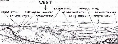
MILE 64.4, HENSLEY HOLLOW OVERLOOK. Elevation 2,560 feet. The
sketch names the principal features of the view. The cleared strip that goes
over Lick Ridge is not a road, but a power line. The town of Elkton is shown
on the sketch. The town of Shenandoah is on the far side of the Valley, and
just to the left of Huckleberry Mountain. The relatively nearby ridge this
side of Grindstone Mountain has no name on the maps.
 |
| View from Hensley Hollow Overlook |
|---|
History: The town of Elkton, at the junction of routes 33 and 340, began
on the bank of the Shenandoah River at the mouth of Elk Run. It was named
for Elk Run in 1881. Before that it was called Conrad's Store.
Geology: The rock exposed in the road cut across the Drive is of the Swift
Run formation. It's mostly phyllite—a slaty rock with lustrous surface in a
fresh break, due to thin scales of mica. This is hard to see on the weathered,
lichen-covered rock. But it's easily seen where the rock is disintegrating,
and you can pick up a freshly broken piece from the bottom of the rock face.
MILE 64.5, Wildflower note: The feathery flowers that grow on the bank
on the east side of the Drive, blooming in late May and early June, are
Allegheny goatsbeard, Aruncus dioicus, a member of the rose family.
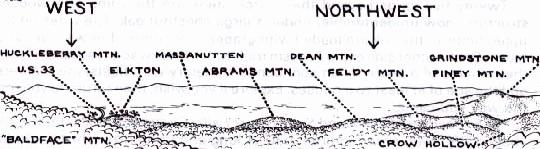
MILE 64.9, PARKING PULLOUT, west side. This parking area is not an
overlook but the site of the former Swift Run entrance station. There's a
view of sorts from the north end. To the left you can see some of the ridges
in the South Section of the Park. Hanse Mountain, a little to the left of
center, is mostly hidden by the trees. The town of Elkton is a little to the right
of center.
Wildflower note: There are dogwood trees on both sides of the Drive in
this area. They bloom in early May. In some years they put on a spectacular
show; in others the bloom is skimpy. It all depends on the weather.
|